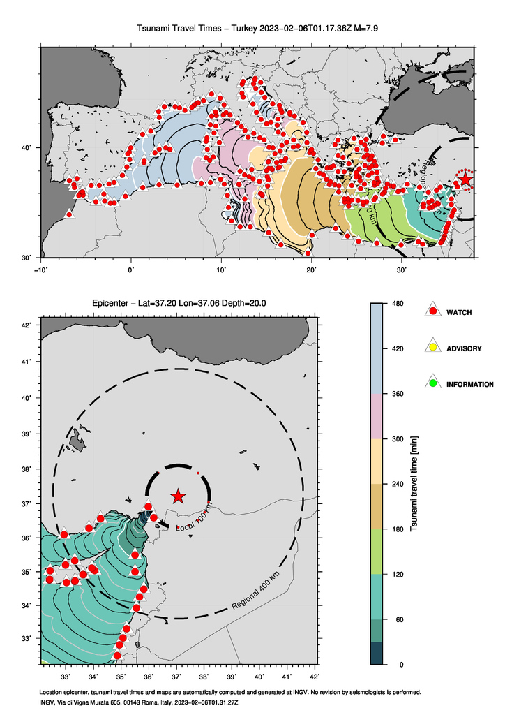
 The earthquake occurred this night in Turkey has generated a Basin Watch tsunami warning. The figure shows the isochrones (lines that theoretically connect all points reached by the tsunami in a given time interval from the origin and measured on the forecast points represented by triangles that according to color shows the warning level. In this case all the mediterranean coast recieve a red alert.
A 7.9 magnitude earthquake was localized today, Feb. 6, 2023 at 02:17 Italian time (01:17 UTC) in Kahramanmaraş province, southeastern Turkey bordering Syria. The earthquake occurred at an approximate depth of 20 km at the coordinates: Lat. 37.19, Lon. 37.17.
The high earthquake magnitude and hypocentral location, based on the decision matrix used, activated the tsunami warning center services responsible for the area of the event (Tsunami Service Provider) including KOERI (Turkey) and CAT-INGV (Italy), which issued Basin-Watch (red) level tsunami warning messages for the entire Mediterranean basin. After the first message was sent, researchers on duty at CAT-INGV examined data from tide gauges positioned in the area close to the earthquake and other Greek islands to check for tsunami and/or sea level disturbances.
At 03:37 Italian time (02:37 UTC), the Tsunami ONGOING message reporting measurements at the Iskenderun tide gauge in the Turkish province of Hatay and the Erdemli tide gauge in the province of Mersin, with amplitudes in the range of 12-14 cm and period of about 7-9 minutes, was issued. On-duty staff continued to monitor sea level data from the tide gauges located along the Turkish and Greek coasts to the tide gauges of ISPRA's Italian Mareographic Network installed on the Italian coasts of Puglia, Calabria and Sicily.
As no significant changes in the tide gauge signals were observed, at 07:02 Italian time (06:02 UTC) the alert was closed (ENDING).The area affected by tonight's earthquake is considered one of the most seismically active regions in the Mediterranean. In fact, Turkey is located in a highly seismic zone crossed by numerous fault systems as shown in the map of the World Scale Hazard Model produced by GEM (https://www.globalquakemodel.org/gem-maps/global-earthquake-hazard-map).
✉️ First Basin-Watch alert message (English).
✉️ Ongoing (second) Basin-Watch message (English).
✉️ Ending alert message (Inglese).


