

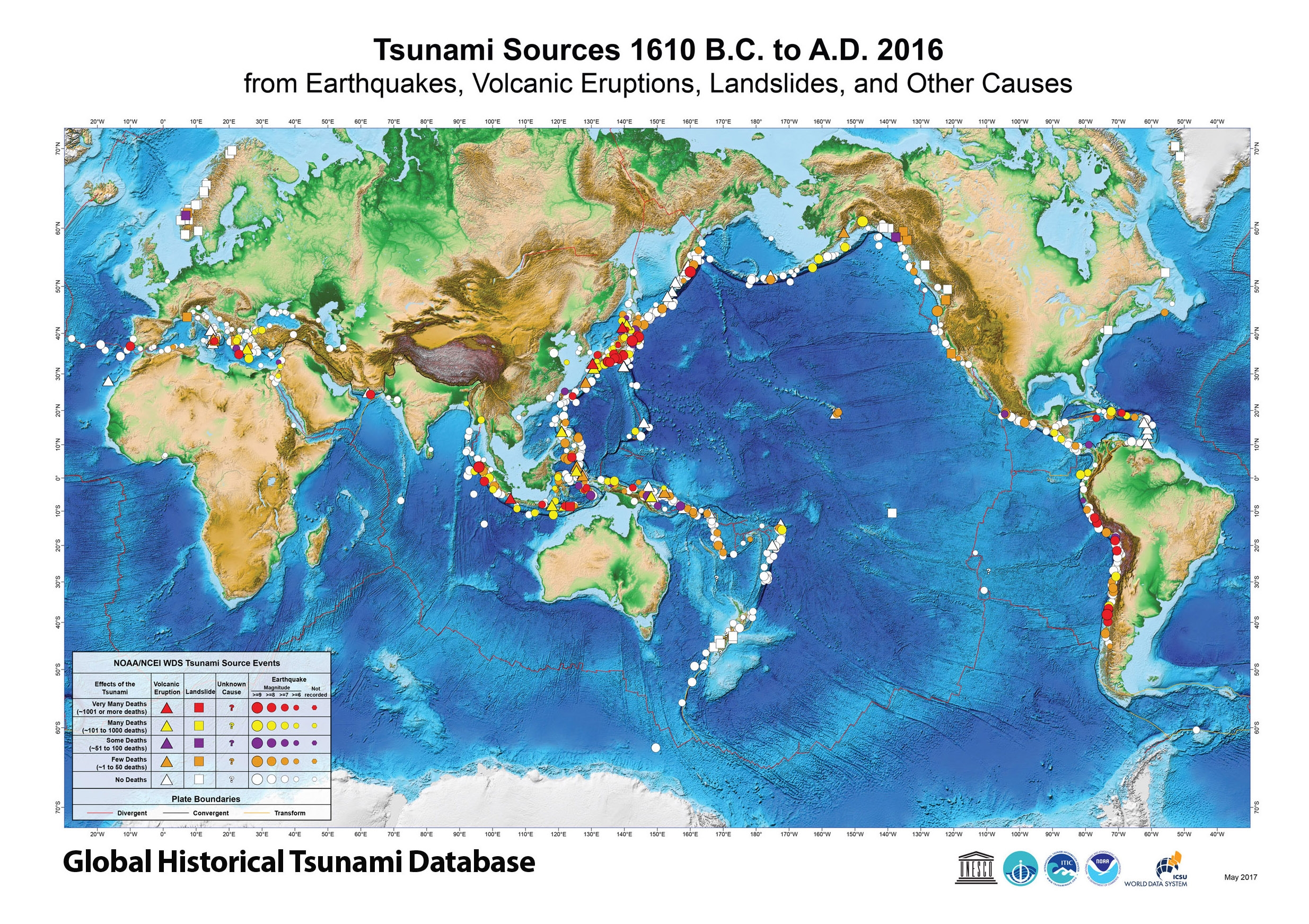
Tsunami distribution in the world
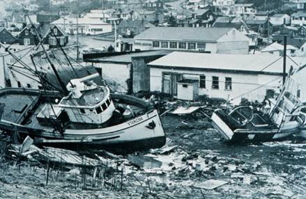
Effects produced by the Alaskan Tsunami (1964) in Kodiak (Alaska). The boats in the photo were transported to the city by the waves, a few dozen metres from the coast..
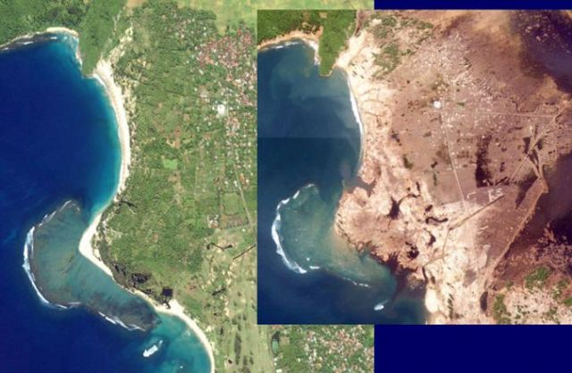
Satellite image showing the Banda Aceh region before and after the tsunami..
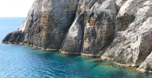
The rise of the coastline in Sougia (Crete) caused by the earthquake of 365 A.D. © Jack Mason, 2014
Most tsunamis (about 80% of the total) are generated by strong underwater earthquakes; to a lesser extent by volcanic eruptions and landslides. The areas of the world where tsunamis are generated more frequently and with greater intensity are those where the geological movements are more intense, i.e. at the edges of tectonic plates, where both earthquakes and volcanic eruptions are frequent.
The area most affected by these phenomena is the Pacific Ocean, where most of the events are concentrated along the "circum-Pacific belt" (Pacific rim), also known as the "ring of fire" due to the presence of as many as 452 active or dormant volcanoes, some of which are among the largest in the world, such as Saint Helens in the US, Popocatepetl in Mexico, Cotopaxi in Ecuador and Mount Fuji in Japan, to name just the most famous. Along this ring, almost 40,000 km long, eight tectonic plates meet the great Pacific plate, the Nazca plate and the Cocos plate.
Other very active seismic and volcanic areas are those located in the Indian Ocean, along the Sunda Trench, and the area which delimits the Australian plate and the Pacific plate, between Papua and the Solomon Islands.
Tsunamis, both destructive and minor, also occur in the Atlantic Ocean and the Mediterranean Sea. It has been estimated that 14% of the historically documented tsunamis occurred in this area, where the African and European plates collide.
One of the four UNESCO-IOC Intergovernmental Coordination Groups deals precisely with the northeast Atlantic and the Mediterranean (NEAMTWS).
The five strongest earthquakes during the last hundred years have generated as many destructive tsunamis, four of which occurred along the Pacific Ring of Fire (in Chile, Japan and Alaska), with the sole exception of the 2004 Sumatra tsunami, which hit the Indian Ocean instead.
On 22 May 1960, the strongest earthquake of the 20th century, known as the Valdivia earthquake (Magnitude 9.5), took place in Chile and was followed by a violent tsunami with waves 15-20 metres high on the coast near the epicentre. The tsunami reached Hawaii about 15 hours later, with waves locally exceeding 10 metres. After about 22 hours, the coast of Japan (about 10,000 km away) was also hit by the tsunami with waves up to 6 metres high.
On 27 March 1964, an earthquake of magnitude 9.2 in Alaska produced a violent tsunami with waves which spread as far as Hawaii. The wave propagated along all the American coasts of the Pacific and California, hitting them with heights between 2 and 6 metres.
On 26 December 2004, an earthquake of magnitude 9.1 off the coast of Sumatra caused the most destructive tsunami of the century, both as concerns the effects it produced and in relation to the affected area. No other known tsunami of the past has caused so many victims (almost 230,000, according to official UNESCO estimates) and damage in so many areas of the world. In addition to Indonesia, the waves hit all the states of the Indian Ocean, causing damage in Somalia, Kenya, Tanzania, Madagascar, Mozambique, Mauritius, South Africa and Australia. The tsunami crossed the Atlantic Ocean and the Pacific and was also detected, more feebly, in New Zealand, Antarctica and along the coasts of South and North America.
In 2011 an earthquake of magnitude 9.1, with epicentre about 70 km off the northeast coast of Honshu Island, Japan, generated a tsunami with waves reaching and exceeding 40 metres in the Iwate and Miyagi prefectures, with an ingression of almost six kilometres in Sendai. The wave spread throughout the Pacific, reaching Alaska, the Hawaii Islands, the coasts of North and Central America and Chile. On the Chilean coast, 17,000 km away, the tsunami was 2 metres high at its arrival on the coast. The official number of victims of the event, most of them related directly to the tsunami, was 15,704 people.
The fifth major earthquake of the last hundred years occurred off the Kamchatka peninsula, on the Pacific shores of the current Russian Federation, near the island of Paramushir, not far from the town of Petropavlovsk. The earthquake, of magnitude 9.0, generated waves which locally reached 18 metres, causing considerable damage to the Kamchatka peninsula and to the Kuril Islands, especially in the city of Severo-Kurilsk, causing a number of victims estimated at about 10,000-15,000, with 2336 civilians missing according to available official documents. There is very little scientific information available on this tsunami and it remained secret until the 90s of the 20th century. In the Soviet Union at that time it was common practice to keep natural or technological disasters secret: most of the information concerning the event was in fact classified as secret or very secret, and the first news was published only between 1957 and 1959. This cloak of secrecy generated many legends about the tsunami in the eastern islands, which is still today defined as the silent tsunami or the secret tsunami.
A first model of seismic tsunami hazard (S-PTHA) was published by Hayes et al. in 2018.