

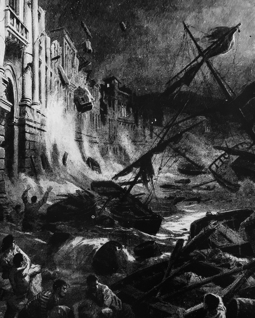
 The earthquake and tsunami of Messina in an illustration from the time
 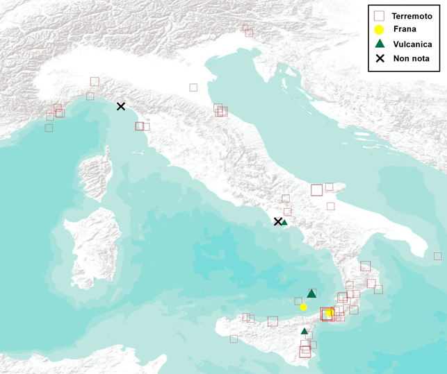 Map of the best documented Italian tsunamis from 79 AD to 2014. The symbols refer to the different cause of the tsunami and are proportional to the Intensity (from Maramai et al., 2014)..;
Italy is a country in which numerous well documented and publicly known earthquakes and volcanic eruptions have occurred. Historical sources testify that these calamities have characterized the history of our peninsula since ancient times. But not everyone knows that the Italian coasts of the past have also been affected by tsunamis, both of low magnitudes and more destructive ones, as is evinced by the study of historical sources, texts written by direct witnesses, and chronicles describing the effects of these historic tsunamis.
The low awareness of the tsunami risk in Italy probably lies in the fact that the tsunamis, fortunately, occur less frequently than earthquakes, and that the last disastrous tsunami in Italy dates back to over a century ago. This is the tsunami originating from the catastrophic earthquake of Messina in 1908.
The bibliographical sources testify that a few minutes after the quake, a destructive tsunami hit the coasts of eastern Sicily and Calabria, adding destruction and death to an already devastated area. Despite numerous attempts, it has not been possible to estimate the number of victims caused by the tsunami compared to those caused by the earthquake. In many places the tsunami occurred with an initial withdrawal of the sea (in some places up to about 200 m) which lasted for a few minutes (Baratta, 1909).
Then the sea hit the coast with at least three big waves. In some locations the largest wave was the first, while in others it was the second. On the east coast of Sicily, the tsunami was very violent, especially between Messina and Catania: in S. Alessio the water reached the maximum height (runup) of 11.90 meters above sea level. Tsunami effects were also observed along the northern coasts of Sicily, up to Termini Imerese.
A similar situation occurred on the Calabrian coast: a run-up of 13 m was measured at Pellaro, south of Reggio Calabria, and effects were also observed in Tyrrhenian Calabria up to Porto S. Venere. The tsunami waves spread south to the coasts of Malta, causing the flooding of streets and shops and, to the north, were recorded by instruments located in Naples and Civitavecchia, over 300 and 500 km away, respectively.
Although such devastating events are fortunately rare, the tsunami of 1908 documents that even the Italian coasts, especially those of Calabria and Sicily, are exposed to the risk of large tsunamis. More likely, however, are events with less intensity but that are still dangerous for those near the coast.
The figure shows the geographical distribution of the events (earthquakes and volcanic eruptions) that gave rise to the tsunamis that have occurred along the Italian coasts and were well documented by historical sources. In total from 79 AD to today, we know with certainty that about 70 events of this nature have affected the Italian coasts.
However, only some of these have had destructive effects. Tsunamis in Italy, and in general in the rest of the world, are mainly caused by submarine earthquakes or earthquakes whose epicentre is on land very close to the coast. Volcanic eruptions and landslides - sometimes triggered by earthquakes - can also generate tsunamis.
Recently, the Database of tsunami observations in Italy has been published which collects the data of the cited catalogue and allows their visualisation in various forms (Maramai et al., 2019).
Finally, in 2018 the first probabilistic model for tsunami hazard of seismic origin was published for the Mediterranean area and the north-eastern Atlantic (TSUMAPS-NEAM), the result of a European project coordinated by the INGV, which is described here.