

 A 2018 seismic event in Hawaii detected by the global seismic network used by Early East to locate earthquakes and calculate the magnitude.
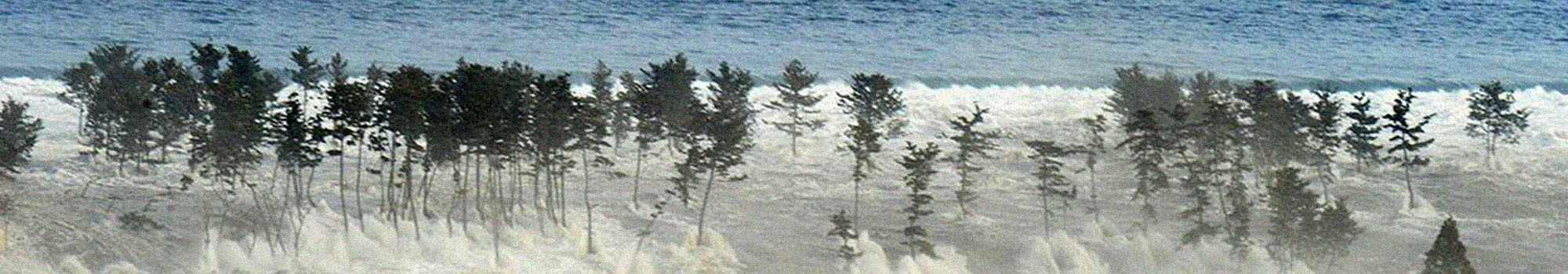
Some large earthquakes, whether they occur under the seabed or near the coast, can cause huge amounts of water to move vertically. The rupture within the earth's crust starts at a point where the rocks are more fragile and spreads at a speed varying between two and three kilometres per second, extending across the entire fault for tens of kilometres or, in the most destructive earthquakes, for hundreds of kilometres in length. The resulting seabed shift causes the sudden rise, even by a few metres, of vast areas of sea and the lowering of others. This generates an imbalance which involves billions of cubic metres of water: the tsunami is nothing more than the return of the masses of water to a state of equilibrium. Unfortunately, however, in doing this, the sea, at least in part, comes out of its natural bed and invades the land advancing in the form of successive waves. By crossing the oceans, tsunami waves carry energy even over great distances and in the open sea they can reach a speed of several hundred kilometres per hour (up to 800 km/h in the middle of the Pacific), a speed which reduces to a few tens of kilometres per hour as they approach the coast and the depth drops favouring an increase the amplitude of the wave as a result of energy conservation. For more details on tsunami dynamics click HERE.
The rupture of the earth's crust, which is at the origin of the earthquake, has a second effect: it generates "solid" waves inside the crust, that is, oscillations, compressions and expansions of the solid matter, called seismic waves, which travel through the crust. Unlike tsunami waves, seismic waves rapidly lose energy as they move away from the rupture which generated them, but they can reach speeds of more than 10 kilometres per second, i.e. almost 40,000 kilometres per hour. For example, if there were a strong earthquake at sea near the island of Crete followed by a tsunami, the seismic waves would reach Italy in less than two minutes, while the tsunami would arrive on the Sicilian and Calabrian coasts after almost two hours.
Unfortunately, seismic waves are very destructive near the breaking point of the fault and are at the origin of the devastation and collapse which occur in the epicentre areas. However, these same seismic waves, because of their speed, allow detecting potential tsunamis.
In fact, seismic waves arrive on the coast long before tsunami waves (they are at least fifty times faster), and their destructive potential decreases greatly as the distance increases. However, precisely because they are fast, they can be used to understand in advance whether the earthquake may have generated a tsunami. For this reason, the fastest way to launch an alert for tsunamis generated by an earthquake is to observe the seismic waves recorded by special networks of sensors called seismometers. The analysis of these recordings allows to locate an earthquake in a few minutes and to calculate how much energy it emitted, even if the earthquake occurs at sea, away from the sensors.
There are some networks of seismometers, called "global", used to locate large earthquakes occurring anywhere on earth. These are made up of sensors installed all over the Earth. The first global network, called World-Wide Standardized Seismographic Network (WWSSN), was created in the United States of America in the early 1960s. It was designed to be able to locate not only earthquakes but also nuclear explosions, which generate, inside the crust, waves of solid matter very similar to those generated by earthquakes.
The modern evolution of the WWSSN is called Global Seismographic Network (GSN): it is a permanent digital network of more than 150 state-of-the-art seismic sensors, operated in collaboration by the USGS (the US Geological and Geophysical Service), the National Science Foundation (NSF ) and the IRIS university consortium (Incorporated Research Institutions for Seismology), with over 150 modern seismic stations evenly distributed across the globe.
A second global network, the GEOSCOPE network, was created in 1982 by Institut de Physique du Globe de Paris; to date it consists of 33 sensors. The third global network, called GEOFON, was set up at the end of the 1980s on the initiative of the GeoForschungsZentrum (GFZ, Earth research centre) in Potsdam.
Today, it collaborates with more than 50 international partners and consists of about 80 high quality seismic sensors distributed throughout the globe, but with a greater number of instruments in Europe and the Indian Ocean. Its current configuration has been designed to make it possible to send an alarm message in the event of a tsunami in the Indian Ocean.
In the Mediterranean there are four seismic surveillance centres which can issue an alert in the event of a tsunami: the CAT-INGV (Tsunami Alert Centre), located in Italy, the Centre d'Alerte aux Tsunamis (CENALT) in France, the Hellenic National Tsunami Warning Centre (HL-NTWC), established at the National Observatory of Athens, Institute of Geodynamics (NOA/HL-NTWC) in Greece and the Boğaziçi University Kandilli Observatory and Earthquake Research Institute - Regional Earthquake-Tsunami Monitoring Centre) (KOERI-RETMC) in Turkey.
Localising an earthquake and assessing its magnitude are all the faster and more precise the more the sensors used are numerous and close to the epicentre. For this reason, the four centres have agreements which allow to share in real time the signals recorded by their national seismic networks.
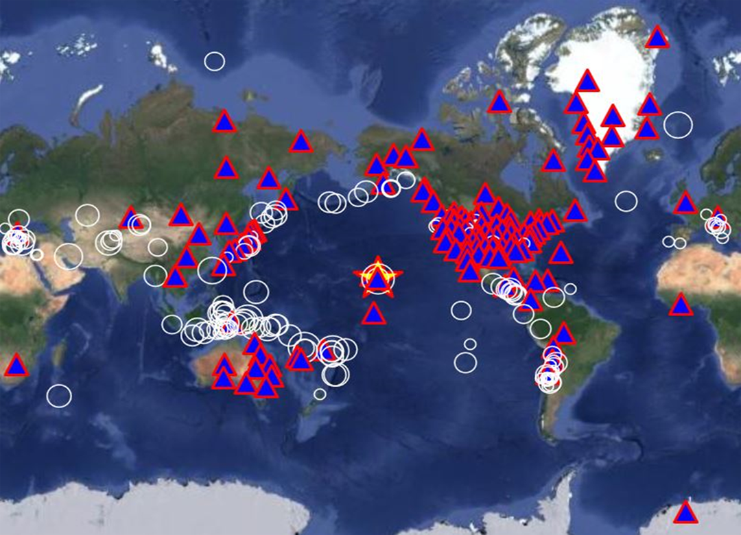
These signals, together with those from the three global seismic networks described in the previous paragraphs, constitute the primary information for launching a tsunami alert. Figure 1 shows the map of the seismic stations, installed on 6 continents, used at the Tsunami Alert Centre of the I.N.G.V. to locate an earthquake of magnitude M 6.6 which caused a small tsunami at the Hawaiian Islands on 4 May 2018, just one day after a major eruption of the volcano Kilauea began.