

 Un messaggio del CAT-INGV in Inglese
  The volume published on the occasion of the tenth anniversary of NEAMTWS
The Tsunami Alert Centre of the INGV (CAT-INGV) is an integral part of an international system for tsunami risk governance, the ICG/NEAMTWS (Intergovernmental Coordination Group for the Tsunami Early Warning and Mitigation System in the North-eastern Atlantic, the Mediterranean and connected seas), as described HERE (LINK). At national level, the CAT-INGV is part of the SiAM (National Seaquake Alert System), established in 2017 by a Directive of the President of the Council.
The ICG/NEAMTWS is responsible for coordinating the development and the activities of the alert centres throughout the area. The two levels of the system must necessarily be coherent with each other, combining on the one hand the need to ensure maximum uniformity of criteria, procedures and operational standards and on the other the need to adapt to the architecture and the specific needs of different Civil Protection systems at national level.
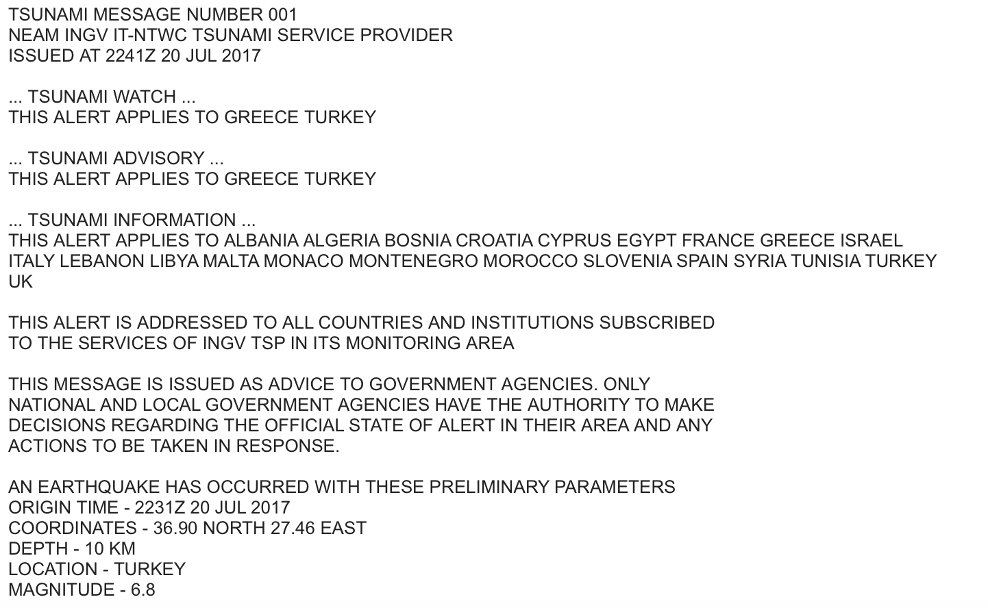
The CAT-INGV operates as a Tsunami Service Provider, not only for Italy but for the entire NEAM region. More precisely, the CAT-INGV has the task of sending the alert messages (in English) to the countries of the NEAM area which have signed up to the monitoring and alert services. In its role as a Tsunami Warning Focal Point (TWFP), the CAT-INGV in turn receives data and alerts from other countries in the NEAMTWS system.
The CAT-INGV sends the same messages, in Italian and with a system based on regions and alert levels, to the Civil Protection Department, which is responsible for disseminating the alert, confirmation, cancellation and event end messages to local authorities (municipalities, prefectures, regional operating rooms).
The international dimension of the CAT-INGV does not only concern the offer of services, but also the collection of data, which is fundamental to ensure the quality of the estimates made and the functions of the centre itself. The CAT-INGV works, in fact, within a network of government agencies and scientific institutions which, through bilateral agreements, collect and exchange data in real time on seismic phenomena and sea level.
The accuracy and timeliness of these estimates are crucial, and depend also on the number of instruments and on the ability to manage the exchange of data produced. The monitoring and evaluation of earthquakes which can generate tsunamis is carried out using both the National Seismic Network and other regional and global seismometer networks. As regards the sea level data required for confirmation or cancellation of an alert, the CAT-INGV uses data from the National Tide Gauge Network stations managed by ISPRA (LINK TO SHEET) and from the tide gauge stations of other ICG/NEAMTWS countries.
The exchange of seismic and tide gauge data is regulated by international agreements between the governments of the countries involved. The CAT-INGV makes its estimates and assessments using all available data, in turn, making these available to other research institutes. The instrumental coverage of the seismic network depends on the accuracy of the location of the earthquake, the estimate of its parameters, and on a first rapid estimate of the potential to generate tsunamis; on the basis of this information the theoretical arrival times of the first tsunami wave at specific points (Forecast points), for which an alert level is also estimated, are then calculated.
The confirmation that the earthquake detected has actually produced anomalies in the sea level and what their extent is can be carried out through the analysis of tide gauge data; similarly to seismic data, the accuracy of this assessment depends on the number and geographical distribution of the tide gauge stations.
For the system to work, it is essential that all data be processed according to methods and procedures validated within ICG/NEAMTWS. However, it should be noted that the ratings and estimates provided by the Tsunami Service Providers for a certain area may differ slightly. Each centre works independently, using different evaluation protocols, tools and software, within a specific organisational and legal context. As a result, the estimates of magnitude, location and alert level for the different zones may vary from country to country. These differences do not necessarily imply errors or negligence, they are solely the consequence of using different instruments and organisational processes.
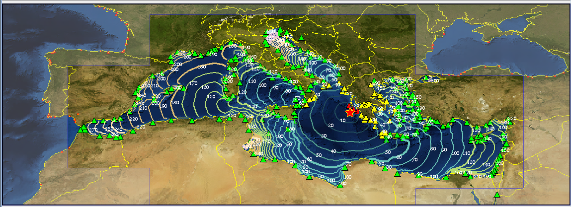 Isochrones (lines which theoretically connect all the points reached by the tsunami wave in a given time interval from the origin) and alert levels for the Zakynthos event of 25 October 2018