

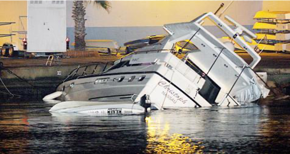
 On May 21, 2003, an earthquake of magnitude 6.8 occurred offshore the Algerian coast, causing a tsunami that affected the Western Mediterranean Sea. Photo shows the effects observed in the tourist port of Ibiza, one of the Spanish islands composing the Balearic archipelago.
 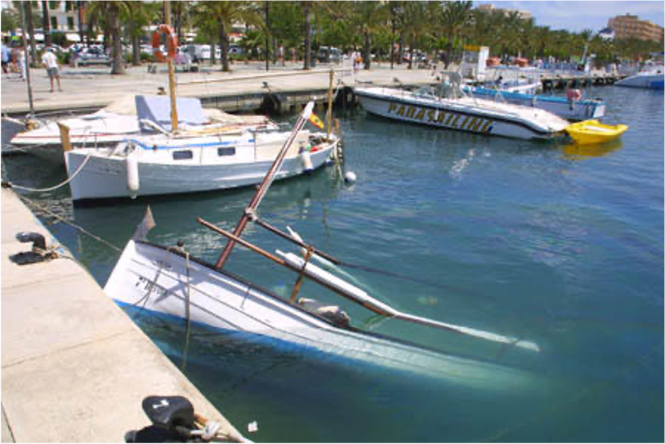 Tsunami effects in Ibiza harbor, Spain
 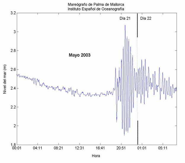 The sea level change caused by Boumerdes tsunami and recorded by the mareograph installed in Palma de Mallorca harbor, Spain.
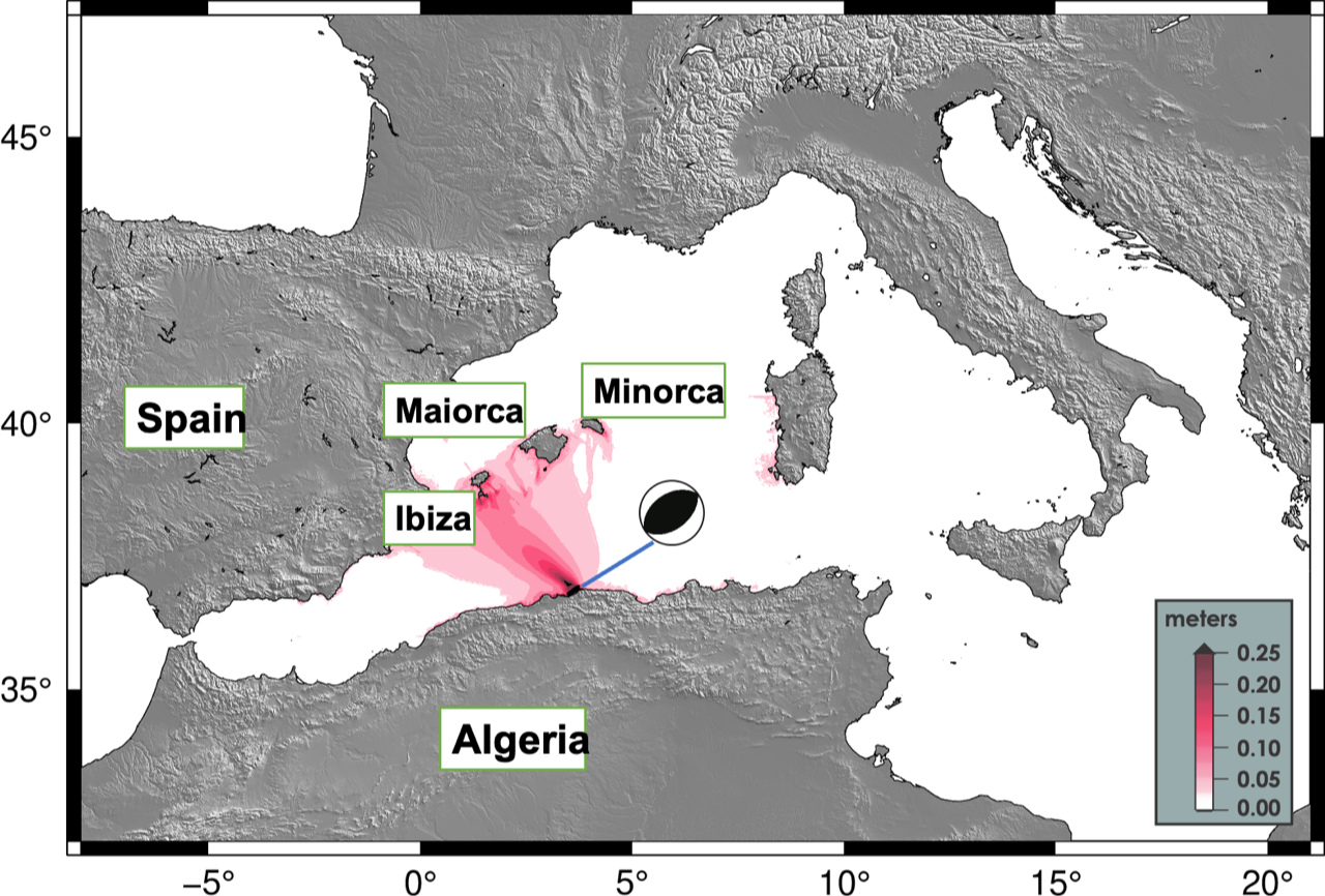
The image shows the simulation of the maximum amplitudes range reached by the May 21, 2003 tsunami. The largest run-up measurements (the maximum topographic height reached by the tsunami), identified by a deeper red color, were recorded in Algeria, in the areas facing the epicenter and along the Spanish coast, particularly in the ports of the Balearic Islands. Sea level changes, which did not cause damage, were also observed along the coasts of Western Sardinia (Italy).
On May 21, 2003 at 8:44 p.m. local time (18:44 UTC) a 6.8 magnitude earthquake occurred in the Western Mediterranean Sea offshore Algeria (geographic coordinates lat. 36.54, lon. 3.36).
The earthquake originated along the northern Algerian seismogenic structure, where the African plate collides with the Euro-Asian plate generating earthquakes of great magnitude e.g., the events that occurred in 1715, 1954, 1980 (M 7.3), 1989 (M 7), 1994 (M 5.6), 1999 (M 5.8) and 2021 (M 6.2).
The earthquake caused severe and widespread damage between Zemmouri and Boumerdès towns. The shift of the fault also cut through telecommunications cables lying on the seabed, interrupting communications between Europe, Asia and the Middle East.
The fault movement raised the seafloor about 40 to 80 cm, consequently pushing the overlying water column and triggering the tsunami.
Eyewitnesses, from the Algerian coast, described a rapid sea withdrawal of about 100 meters between the cities of Algiers and Boumerdes. Fishers, from Zemmouri-El-Bahari harbor, reported that the sea level decreased by at least 1 meter, leaving boats dry in the harbor.
The tsunami also caused severe damage along the Balearic Islands coasts, particularly on the southeastern coasts of Majorca and Menorca (Spain), which are approximately 250 km from the earthquake epicenter. Sea level changes of more than two meters "peak-to-peak" (the difference between the negative peak value and the positive peak value) were observed at mareographs positioned in the ports of the Spanish islands. Hundreds of boats moored in ports were damaged by tsunami waves, and in Puerto de Mahon, tsunami damaged 10 boats.
The tsunami was observed along the coast of Spain, in Alicante, Castellon and Murcia. Sea level changes caused by tsunami were also recorded by mareographers in France, in the Nice ports and in Italy, especially in Genoa.
On March 18, 2021, a 6.2 magnitude earthquake occurred in the area. The earthquake had a sea epicenter and a depth of 13 km. The earthquake parameters triggered the Tsunami Alert Center, which, within 10 minutes of the earthquake's detection, issued an Advisory alert message for the Algerian coast close to the epicenter and an information message for other Mediterranean Sea coasts where the tsunami was unlikely to produce a significant impact (including Italy). More details on the event page.