

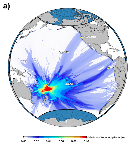
 three strong earthquakes were recordedFigure shows the maximum wave amplitude distribution of tsunami waves in the far field associated with the 2021 Mw8.1 Raoul Is. earthquake (Romano et al., 2021)
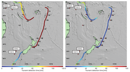
The figure (Fry et al., 2020) shows the faults associated with seismic activity in the southwest Pacific. The colours indicate the time to detect a tsunami generated along one of these faults using the DART buoy network. The left panel shows the detection times for the array before the new New Zeland network installation (right panel).
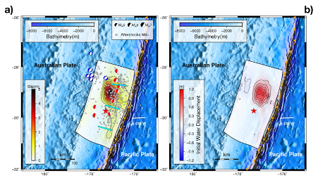
Figure shows a) the coseismic slip distribution of the 2021 Mw8.1 Raoul Is. earthquake (Romano et al., 2021), and b) the distribution of the initial water displacement associated with the earthquake. In particular, the limited seafloor deformation limited in turn the coastal tsunami impact despite the large earthquake magnitude.
On March 4, 2021, three strong earthquakes were recorded - within a few hours - in the Tonga-Kermadec subduction zone between New Zealand and the Tonga Islands Archipelago in the Pacific Ocean.
The first earthquake, magnitude 7.3, occurred at 2:27 a.m. (local time) offshore East Cape, New Zealand, followed by a second magnitude 7.4 earthquake that occurred at 6:41 a.m. off Raoul Island, the largest island among the Kermadec Islands archipelago. The strongest sequence earthquake, magnitude 8.1, was recorded at 8:28 am, located about 50 km east of the 6:41 am event.
The three earthquakes generated tsunami waves that, although locally affecting the coasts of neighboring islands and New Zealand, did not cause casualties or evident damage to coastal structures.
The INGV Tsunami Alert Center researchers, in collaboration with the GNS Institute of New Zealand and the University of Naples Federico II, analyzed the signals recorded by 7 tide gauges and five pressure sensors of the new DART (Deep-ocean Assessment and Reporting of Tsunamis, Fry et al., 2020) network of New Zealand, recently installed to improve the rapid detection capability of tsunamis in the Southwest Pacific Ocean.
This series of events allowed to test for the first time the new DART sensor network, whose implementation (for a total of 12) is expected to be completed in 2022.
The study led by Fabrizio Romano (INGV) and recently published in the scientific journal Geophysical Research Letters (LINK ARTICLE) presents the tsunami source reconstruction obtained using signals recorded by the DART network and tide gauges.
This study also showed that these sensors, placed offshore and at high depths, provide a means of effective, early and direct tsunami measurement, allowing to issue tsunami warnings much more accurately than those issued from seismic wave measurements alone. The new DART network, when completed, will greatly increase the time available to evacuate the population by reducing alert latency.