

 Effects of the tsunami in Talcahuano. Many boats, even large ones, carried inland by the tsunami. Photo: Martin Bernetti - AFP/Getty Images.
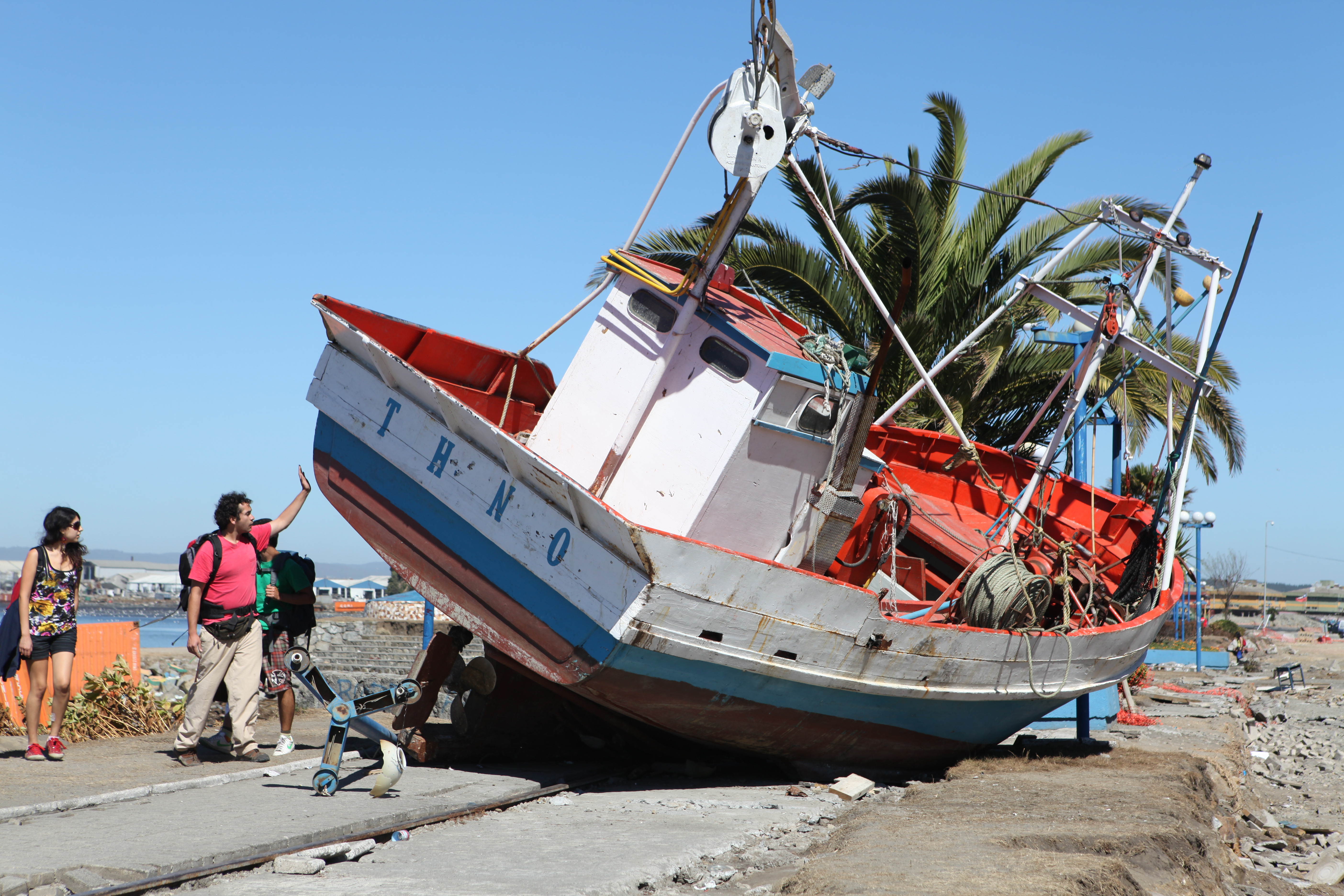
Credit: Walter D. Mooney Ph. D., U.S. Geological Survey. Public domain)
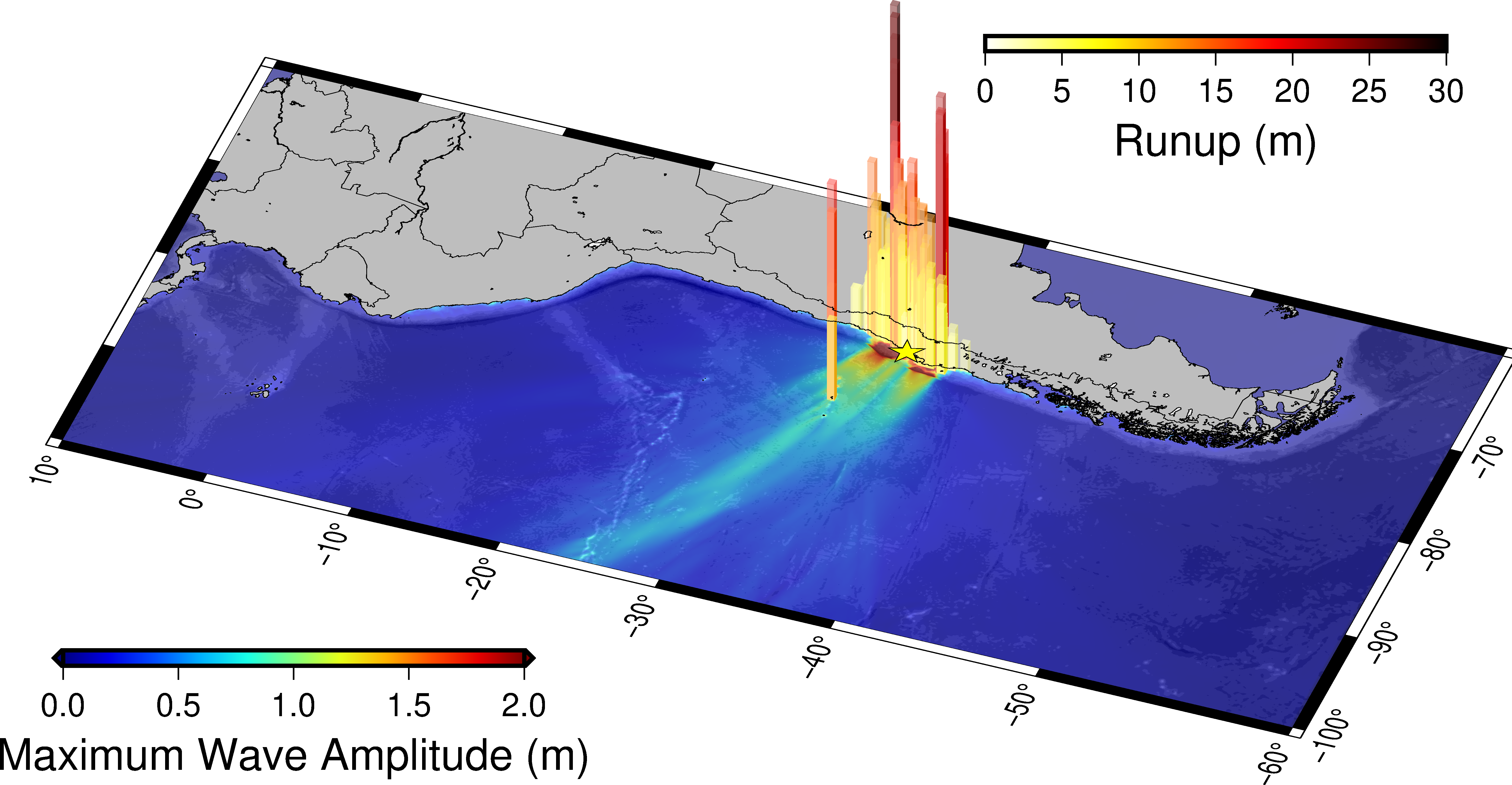 The image shows the distribution of runup measurements (the maximum topographic elevation reached by the tsunami) collected during the post-event campaigns in Chile (NOAA NGDC database) and the range of maximum amplitudes of the simulated tsunami in the Pacific Ocean
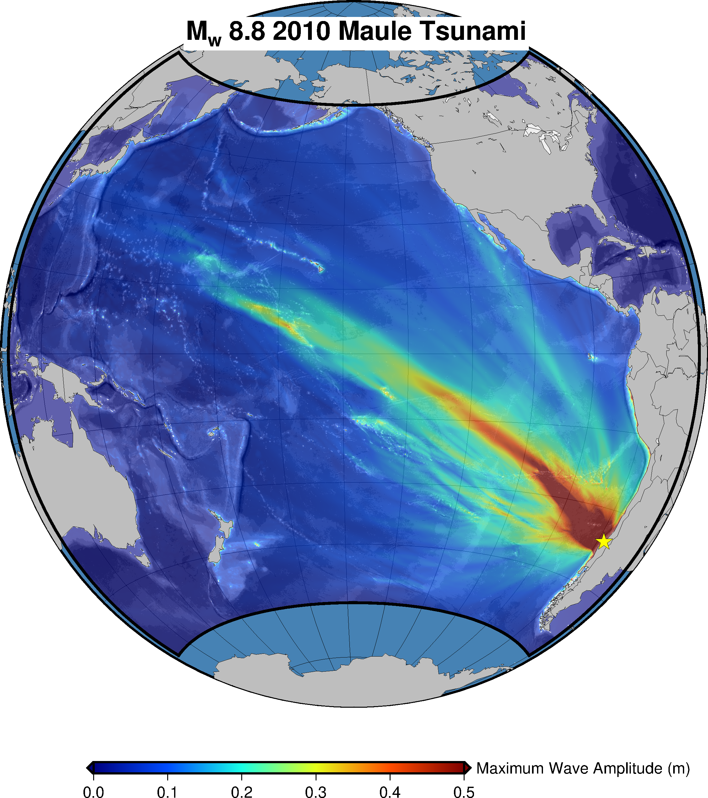 The image shows the range of maximum amplitudes of the simulated tsunami in the Pacific Ocean.
On February 27, 2010, a very large earthquake, of moment magnitude Mw = 8.8, struck Chile, between the provinces of Maule and Bio Bio. The earthquake epicenter was located along the central Chilean coast, about 325 km south of the capital Santiago, and it was felt as far as Sao Paulo in Brazil and Buenos Aires in Argentina, thousands of kilometers away. This was the strongest earthquake in South America in the instrumental era after the 1960 Great Chilean earthquake of magnitude 9.5, which is the strongest seismic event ever recorded on a global scale. The Maule earthquake in 2010 caused a destructive tsunami for the Chilean coast and some islands in the Pacific Ocean, as shown in this animation of the numerical simulation of the tsunami propagation.
The earthquake occurred in one of the most active subduction zones on Earth, which runs along the entire Pacific coast of South America, where the oceanic lithosphere forming the Nazca tectonic plate dips below the continental crust of the South American plate.
The convergence between the plates in the Maule zone occurs at a relative rate of about 7 cm/yr. The friction between the plates deforms them and produces an accumulation of elastic energy that can be suddenly released by earthquakes generating seismic waves and the displacement of the seafloor that can result in a tsunami (Lorito et al., 2016).
In great earthquakes as the Maule event in 2010, the relative movement of the two blocks occurs on very large areas; the estimated length of the rupture, in this case, was about 600 km in north-south direction and the width of the rupture exceeded 100 km, from the oceanic trench in the west to the Andes in the east.
It is important to know that the movement of a large fault, even smaller than the Maule earthquake, can cause significant deformation of the seafloor even if the epicenter of the earthquake is located on land. This is both because the dislocation along the fault begins at one point (the hypocenter) and then propagates and extends over large areas, and also because the seafloor deformation induced by the seismic rupture extends over an area larger than the rupture itself. For this reason, and particularly when a big earthquake occurs inland but close to the coast, tsunami warning systems usually send alert messages even if the epicenter is on land some kilometers away from the coast.
The damages
The damages caused by the ground shaking were extensive, but relatively limited if we consider its magnitude (Mw 8.8), due to the policies of structural prevention implemented by the Chilean authorities after the great earthquake of 1960. Nevertheless, a large number of buildings in several Chilean cities were damaged, with over 300 victims.The tsunami generated by the earthquake caused extensive additional damage to coastal areas and over 150 casualties.
The earthquake source
Many studies on the Maule earthquake have been conducted, and most of the dislocation models obtained for this event identified a bilateral propagation of the seismic rupture to the north and to the south of the hypocentral location. These models agree in identifying two main rupture zones, one to the south of the hypocenter and the other to the north of the hypocenter, with the latter characterized by a maximum dislocation along the fault plane greater than 15 m.
Some research groups (e.g., Yue et al., 2014) identified a dislocation pattern characterized by very shallow rupture, reaching the oceanic trench; this type of mechanism, also observed during the 2011 Tohoku (Japan) earthquake, is very important because it increases the tsunamigenic potential of the earthquake. This finding was corroborated by the results of an ocean floor measurement campaign (Maksymowicz et al., 2017), which identified a seafloor uplift of about 5 m in the proximity of the oceanic trench; this coseismic deformation is indeed consistent with a significant surface dislocation of the fault plane, as highlighted also in a more recent study by Romano et al. (2020).
Tsunami
The tsunami extensively damaged the cities of Concepcion, Constituciòn, Dichato, and Pichilemu. The waves spread throughout the Pacific Ocean, reaching, for example, the San Diego (USA) coast, where some ships broke their moorings and were dragged onto the pier.
The tsunami reached over 700 kilometers of coastline. In the vicinity of the source, run-up peaks (the maximum topographic height reached by the tsunami) as high as 30 meters were measured. In the city of Talcahuano, where the tsunami reached a height (above the mean sea level) of about 5 meters, both houses floating and big ships reaching the center of the city were observed. The destructive waves quickly reached the Chilean island of Robinson Crusoe, in the archipelago of Juan Fernandez, 670 km from the Chilean mainland, destroying many buildings and causing 5 victims.
Constituciòn department firefighters, working in rescue operations in the center of the city, recovered some missing victims on Orrego Island, located at the mouth of the Maure River that flows through the city.
Lessons learned
The scientific-technical and organizational precautions taken in the aftermath of the 2010 tsunami are estimated to have contributed decisively to saving numerous lives during the 2014 tsunami in northern Chile, generated by the large Iquique earthquake (Mw 8.2). The tsunami monitoring and information system in Chile were radically reorganized after the 2010 event.
Indeed, in May 2012, about half a million people participated in the exercise with evacuation in Valparaìso. In the 2014 earthquake and tsunami, about one million people were evacuated or spontaneously left the shores of the affected area, recognizing the strong and prolonged shaking as a possible precursor to the tsunami. Similar improvements in warning and evacuation procedures were observed with the magnitude Mw 8.3 Illapel earthquake, also in Chile in September 2015.
Article written by: Romano, F., Cugliari, L., Lorito, S., Amato, A. (CAT-INGV)